Last month, we were in Zion national park, Utah. During our time there, we hiked Riverside walk, a small paved trail of 2 miles that moves parallel to the Virgin River. The end of the riverside walk is the start of the famous Narrows hike, one of the most famous attractions in the park. We noticed a decent crowd coming from the river end wearing similar kinds of shoes and tops. Almost everyone was with a wooden stick. Those gears appeared to be from some rental company.

Immediately, we decided to hike this trail which looked exciting. Once we returned home, we did some research and found everything about the hike. Basically, there are 2 famous rental shops in Springdale – Zion Guru and Zion Outfitters. We booked rentals online from Zion outfitters which included their Dry-bib package with an additional waterproof backpack.
Package: Dry Bib for 2
Package Contains: Waterproof bib, Neoprene socks and, Adidas Hydro Lace Canyoneering shoes, Wooden stick
Additionals: Waterproof Backpack
Rental Pick-Up Time: 4 PM – 7 PM

There are two approaches to hiking Narrows – Bottom-Up and Top-Down. The Top-Down is a strenuous backpacking/hiking trip for 18 miles and it requires a wilderness permit. The popular approach is Bottom-Up which starts from the Temple of Sinawava in Zion and requires no special permit. We opted for the same.
We planned our hike for Saturday, March 19th. The idea was to go as early as possible to the Temple of Sinawava which has limited parking. Another option was the park shuttles which were closed for the season. We reached one day earlier to Hildale, UT which was like 1-hour drive away from the park. The ideal location would have been Springdale, but we couldn’t find any property for our stay there.
We reached Zion Outfitters, located near the visitor center, at 3 PM on Friday to collect the rentals. The rental pickup time was from 4 PM – 7 PM, so they asked us to wait for an hour. We requested them to provide the gears early to save our time. We tried bibs, socks, and shoes there first and then chose the appropriate sizes. We were asked to choose sticks before leaving. The waiver forms were signed already during online purchase. We went inside the shop and collected the backpack too. The shop is well equipped with hiking stuff and clothing. They informed us that Shuttles are starting from March 19th, the day of our hike, which was just mindblowing.
On the same campus, we purchased sandwiches, protein bars, fruits, and zip-lock bags from Happy Camper Market. During the shuttle season, private vehicles are not allowed on Scenic Drive, so to reach at Temple of Sinawava, either you need to use the shuttle service or you can rent bikes.
We came back to our stay and after having, dinner went to bed early. The first shuttle was at 7 AM from the visitor center, Springdale. This hike is so popular that the visitor center’s parking lot gets full even before 6 AM. So we planned to go early to avoid the crowd and to have a parking spot.
We woke up at 3 AM the next day and left for Zion at 4 AM. Since it was an hour-long drive from Hildale to Zion, we reached the visitor center at around 5 AM. Unlike the daytime, there was no traffic on the road. There were still 10-15 cars parked in the lot. It was windy cold outside, we wore 2 jackets each, collected our gear, and went to the shuttle stop.

The shuttle stop is just in front of the visitor center’s gift shop. We were second in the line, before us was a group of girls going for Angel’s Landing hike (another famous hike in the park). Soon line behind us gets longer, we all were struggling with the bone-chilling wind. There was no shed or anything, so we were sitting there in open. Still, it was a nice experience, everyone looked excited.
Shuttle Service
Period: March 19 to May 21
First Shuttle from Visitor Center: 7 AM
Last Shuttle from Visitor Center: 5 PM
Last Shuttle from Temple of Sinawava: 7:15 PM
5-10 mins before 7 o’clock, a park ranger came and after greeting the crowd he removed the barrier chain to allow everyone to move forward in line. The shuttle came at sharp 7 and many of us onboarded. The masks were mandatory for the shuttle ride.


It was a 40 mins ride to the temple of Sinawava. The driver also showed us the famous Angel’s Landing during the trip. Most of the passengers hopped off for Angel’s Landing hike at stop 6th. Just before our stop, we put the bibs on top of our jackets and got ready for the hike.

We reached the temple at 7:40 AM and after dividing the snacks and other items between us, we used the restrooms and started the hike at 8:15 AM. To reach the narrows, you have to hike Riverside walk (1 mile) which we did last time too, so we finished it quickly without stopping anywhere.


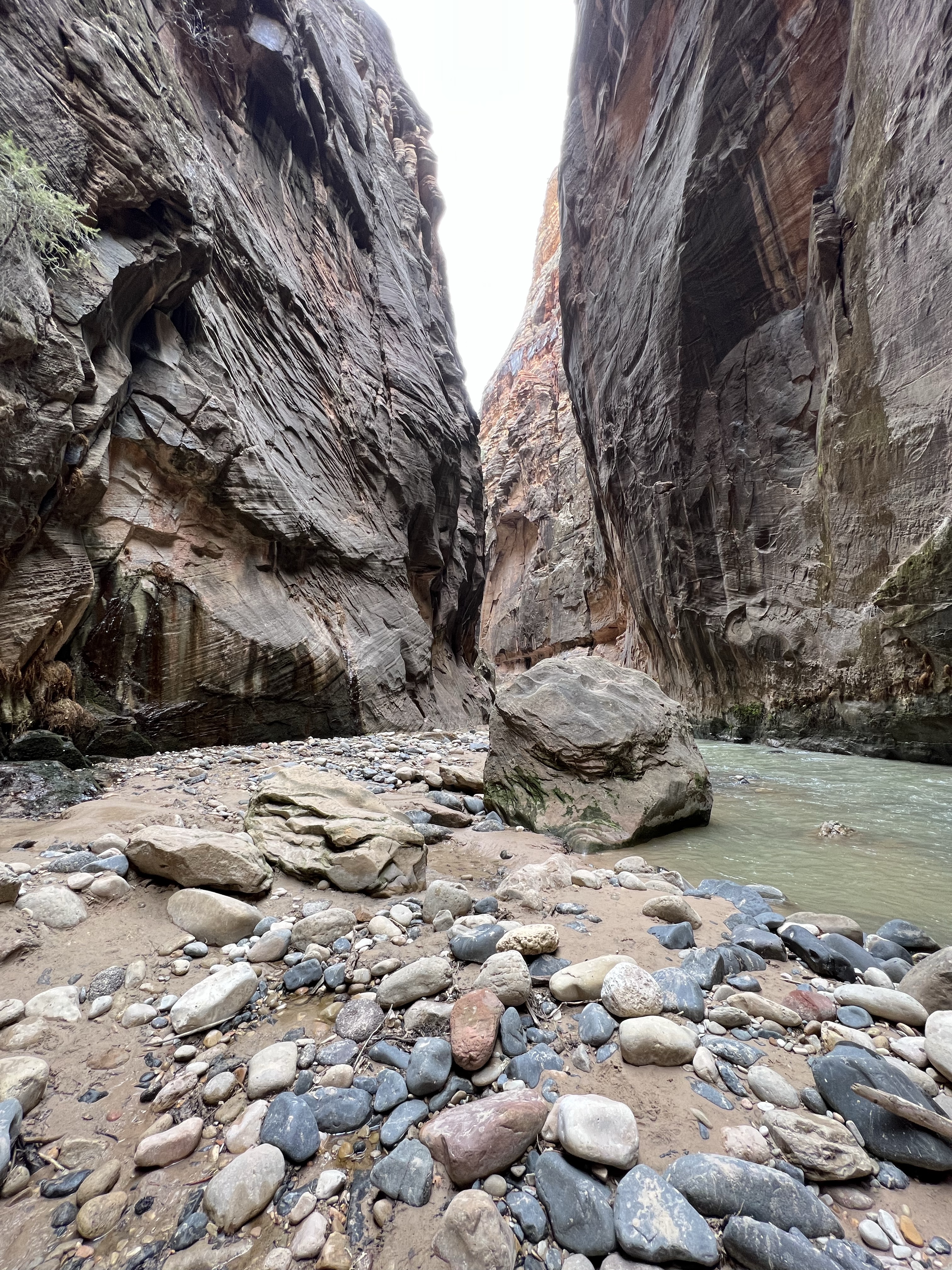
Soon we completed the Riverside walk and came to the same point- Gateway To the Narrows which we visited last month and where we noticed those hikers. I removed my gloves and put them along with Harmit’s iPhone(safely packed in the zip-lock) in the bag. A nice fellow took our picture and we started the hike. At the beginning itself, you have to cross the stream of the river which was cold. It took some time for water to enter inside the shoes. At least we were comfortable.

The only reason for removing gloves was to be able to hold my iPhone properly. I wanted to bring my Sony mirrorless, but it’s not waterproof, so we completely relied on iPhone. Hamit refused to carry her mobile during the hike, so it was my responsibility to get all shots and videos. I didn’t want to miss the opportunity, so one hand was occupied with my mobile while the other with the walking stick. I managed 🙂

In some places, the water was knee-deep but suits were good enough to block the water to enter inside. Nearly 1/2 an hour into the hike, we noticed a thin waterfall which is known as Mystery Falls. Of course, there are no markings or signboards there, you just have to guess the places.

At one place, ice was still melting, creating a small waterfall that was looking amazing. I really wanted to drench myself under it, but everything was so cold. Soon big boulders and deep canyons started to appear. Everything was far better than we expected.

Now the water level came up to the knees and since the water was a little muddy, we had to be extra careful. The river surface was uneven and filled with stones. We maintained our balance with the help of sticks and sidewalls. In some places, the flow of water was too fast, you really struggle to pass through it.

It’s not like you have to be in the water during the whole hike. There were some dry places in-between too. Now there were even more amazing patterns on the walls. I was hoping that iPhone’s battery will last till we complete this adventure(although there was a power bank in the backpack too).


There is no chance to get lost since the trail is pretty straight (no turns). After hiking around 3 miles, we noticed another path on the right side that goes to Veiled Falls. I just took its picture as a landmark and continued the hike. Many fellow hikers returned from this point. This is the start of Wall Street.

Even if you come this far and want to make a return, it will still be worthy. But we wanted to see more, so we continued. Beyond this point, the canyon is narrower and the water level also increases. It was risky now to keep my mobile in hand, so I kept it inside the bib near my stomach (it was tight enough to hold it). I had to take it every time from there when needed.


The next noticeable landmark was the Floating Rock, again there was no marking or anything. But it was looking fascinating lying there in between giant walls. We took a small break there, ate veg sandwiches and drank some water, we were carrying this whole time.

As I previously said, many hikers returned from the Wall Street start point. We had the place almost to ourselves multiple times. There were like 10-12 guys like us who came this far. There was a place where the water level was waist-high.

Harmit was a little tired now, so she inquired how much further we are planning to go. I assured her that if the water level increases further then we will return. I argued, that we have a full day for this hike, so why not complete it? She simply agreed 🙂 (poor girl).


After some time we noticed 2 large boulders (giant actually) which were blocking the path. You actually need to climb on them to continue the hike. A hiker coming from the opposite side told us that from this point the water is chest level and he decided to return from there. We also followed the same (as was the deal with Harmit). We took a final break there and ate another pair of sandwiches. Unfortunately, I forgot to take the picture of that place (full focus on eating). After coming home we realized that was the official end of this hike and that point was Big Spring. After this point, you need a permit to go further.


The return was easier. We didn’t halt much, took some shots, and some selfies, and hurried to finish this adventure. Now the hike was more crowded, and we saw many hikers coming our way.


Till the time we reached Sinawava, the atmosphere became a little hot. We were wearing jackets inside along with warm hats which were not that necessary now. At the Gateway to the Narrows, it was like Disneyworld, with everyone taking selfies and pictures. It was really a wise decision to come early.
After another 1 mile of the walk, we finally reached Sinawava, and luckily there were no lines for the shuttle. There was even a shuttle waiting. We wore the masks and boarded the shuttle.
Overall it was an out-of-the-world experience. We started the hike at 8:14 AM and returned to the Temple of Sinawava at 4:00 PM, that was a total of 8.9 miles as per the AllTrails app (GPS stopped working in-between, so it can be little more than that).

If you are an outdoor person, this hike MUST be on your list. We will create a separate post for Tips and Recommendations for this amazing hike. Please post your queries in the comment section.
Happy Reading! Keep Traveling !!!
Leave a Reply